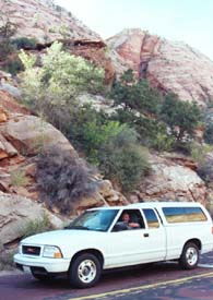
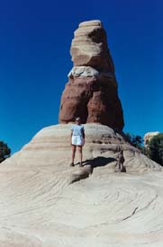
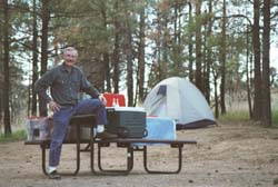
9/15/02 - Sunday - San Diego to Las Vegas
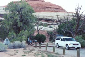
Left at 7 in the morning. After a 4 ½ hour drive to Las Vegas, we checked into the Stratosphere, a hotel on the north end of the strip. Room was big and nice. Paid 29.95 plus $3 tax plus another $3 energy surcharge. Got the deal off the Internet. Settled into our room At 12.30 pm then walked south down the strip. Stopped at the Sahara - Nascar Café for a big old burger and lots of hot fried potatoes. Then continued walking down the strip. Stopped the Wynn Collection. Fancy place - but didn't go to see the art gallery. Admission was $20 for both of us. You can go to the Louvre in Paris for that. Next stop - VENICE at the Venetian. Really liked the place - had gondoliers and fancy shops. We got a Hagen Daas with our 2 for 1 coupon we got at the Stratosphere. Then we went to the Bellagio on the main strip - Really fancy. Had water dancing to music. Looked great, but missed most of the show. The next stop was PARIS - getting a little tired of seeing the world in the span of just 3 miles. Paris was O.K. Last big location was New York, New York - kinda cute, but so exhausted, we didn't really notice much. The display outside by the fake Statue of Liberty had tee shirts of fire fighters from all over the country with hand-written messages. There were so many tee shirts on display. We caught the trolley back to our hotel.
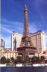
Paris in Las Vegas |
We drank a beer in the room, watched the news and rested. Then we walked another 3-4 miles, this time, north to the downtown district. We walked through some really scary places - were glad we didn't get mugged - didn't feel safe at all. We hung out on Fremont Street. Had a delicious prime rib special for $7.95 - so good, but so sad to see all the fat customers shoveling the food in.
Vegas is NOT our kind of town. We didn't gamble a cent - hate to waste money. We were disappointed in the new hotels. We did enjoy the free light show over Fremont Street. Amazing sight - images cut with lively music displayed over a 1 or 2 block area. OH WOW. We walked home at 10:30 and got back around 11:30. Lots of walking. We were exhausted. Glad the Vegas part of the trip is behind us.
9/16/02 - Monday - Las Vegas to Zion National Park
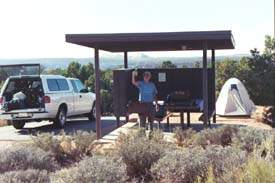
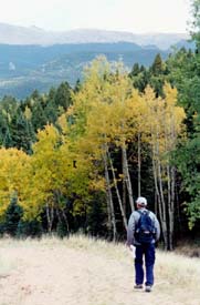
Had a senior's breakfast at I HOP. Good and cheap. Then we had a beautiful 3 - 31/2 hour drive through wonderful scenery. We got to the Watchman campground, set up the tent and had a tuna sandwich.
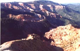
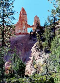
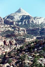
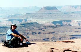
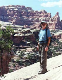
'We caught a shuttle into Zion. We hiked to Angel's Landing - an incredible 5-mile hike with wonderful views. The pioneers who first saw Angel's Landing said, "Only Angels could make it to that place." Thus, the name, Angel's Landing. The trail was very high up with narrow switchbacks (called Walter's Wiggles) along steep drop offs. I didn't look down, so I made it just fine. The trail ended with spectacular views of the entire area. At the top, it started to sprinkle, then thunder. We hurried down quickly. Didn't want to get fried on Angel's Landing.
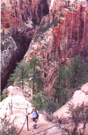
Bill hiking on
Angel's Landing |
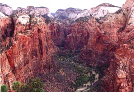
View from the Top
Angel's Landing |
We got down safely and took the shuttle back to the Zion Lodge. We celebrated our hike with an ice cream cone, sold to us by a cute little Polish girl. She's enjoying our wonderful country on some special visa. We watched the rains come down and then went to the Gift Shop to buy Zion a hat and shirt. Then we took the shuttle back to our campsite and made Sloppy Joes for dinner. After cleaning up, we were off to the Ranger's talk. The Ranger was very good. He showed pelts of several mammals that were road kill in Zion. He said he processed the pelts himself. His shared several animal stories:
There was a coyote with the limp, who got more handouts (food) from the campers - so the next season, about a dozen other coyotes developed the same limp.
There were two skunks who befriended him and came to his cabin just to hang out with him while he drank his coffee in the mornings and while he watched the football games on Sunday afternoons. They had an unwritten agreement - The skunks wouldn't spray him if he wouldn't try to pick them up. It worked out rather nicely.
The Ranger told us that more people are injured by deer than by any other animal. We simply don't fear deer because of the "Bambi" factor. One little 9-year old girl was badly mauled by a deer that was trying to get her Cheetos.
The Ranger had so many interesting stories taken from his book.
After the campfire talk, we went back to the tent. I read my book and was annoyed by some other jabbering campers. It was very windy during the night. I think an animal turned over our pot - but Bill said it was the wind.
9/17/02 - Tuesday -- Zion National Park
Slept in until 7, had breakfast, then took the shuttle to the Temple of Sinawava to take the hike up the narrows. We finally got on the trail about 10 or 10:30. It was such a fun, interesting hike. We spent most of the time hiking in the rushing river, knee deep (sometimes deeper). Glad I had Bev's hiking poles. One is never sure of one's footing. The views were spectacular - high narrow cliffs, rushing water. I never took a hike quite like that one before. A little Portuguese man, Claudio (living in New York), wanted to join us. He was a great hiker and so smart. He seemed to intuitively know all best places to cross the streams. He took a lot of videos, but still kept up with us. He did share his yummy oatmeal cookies with us for lunch, so we bonded. We hiked for about 4 hours, up to Mystery Canyon, then explored the canyon before turning back. A young family was hiking along with us. The physically fit Dad kept saying to us, "I admire you people who never stop." I wanted to say, "Shut the heck up. You are ruining the youthful image I have of myself."
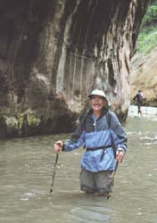
Bill on the Narrows Hike
in Zion |
We finished our hike at 3:30 pm, said good-bye to Claudio and then caught the shuttle to the new museum. The video was really bad - it made me hostile. There was no information, just fluff. We got back to the campsite tired and dirty. No showers and signs posted over the bathroom sinks "Do not wash your hair."; I thought it was a great idea to stick my head under the water and boy, did it feel great. I returned to the campsite a new woman.
We drove to the General Store for ice. We had a beer on the store's front lawn - hope that's OK in Mormon country. Then we drove into Springdale, Utah to dine at the "Bit and Spur." The Bit and Spur was highly recommended by a cute Rangerette who was already planning to have a chili steak there on her next birthday. We had the Mexican combo with the southwestern flair - then drove back to the campground just in time for another Ranger chat. The Ranger / presenter was a sweet little Texas honey who went to A&M. We chatted before the program started. Her presentation was about the different hiking areas in Zion. Nice slides, well organized, but not as good as the program before. Back to the tent -- not as much wind or talk in the campground tonight.
9/18/02 - Wednesday -- Zion National Park - Brianhead
Another late start - too cold to get out of the tent so early in the morning. We had cereal, toast, coffee, juice - the usual, then packed up. On our way to Brianhead, we first stopped at Grafton, a little ghost town where the movie, “Butch Cassidy and the Sundance Kid,” was filmed. The place was miles out on a dirt road - with such scenic views. There were some strange “sculptures” in the area, like an old Cadillac sticking up in the field. We explored the town (just 4 or 5 buildings). I took pictures and went where I shouldn’t go - had a great time. Stopped at the old graveyard on the way back to the main highway.
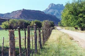
Road to Grafton |
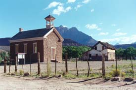
Grafton Ghost Town |
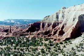
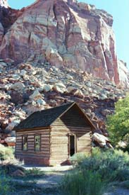
Our next stop was Kolob Canyon, a branch of Zion National Park right off I-15. It starting to get cold and windy. We had a picnic and then hiked to a wonderful overlook - but I had left my camera behind in the truck. Woo is me. So sad because the sandstone structures were awesome. After lunch, we took a 5-mile hike up Taylor Creek to double arch alcove, mostly along the streambed. It was a great hike -- wonderful scenery. We passed by two log cabins.
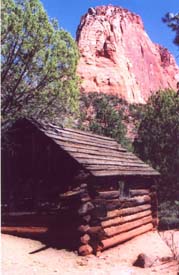
Log Cabin on the
Kolob Taylor Creek Hike |
After the hike, we headed to Cedar City to buy grub at their local Super Walmart Store. It's amazing to see so many huge Walmart's planted in the rural areas. Great store - good food at low prices. The weather was turning bad. The wind was really blowing and we were COLD. Hope this is not a sign of things to come.
Drove on to Brianhead and found Dianne's (Bev's sister) condo. Signs posted in the room said, "Do not turn heater on," but we were cold, so called Kevin, the maintenance guy, to help us out. Kevin was a sweetie pie and got the heater and the fake fireplace going, but no phone and therefore, no Internet. We made a wonderful dinner. Cooked salmon in the George Foreman Grill. Also had corn, baked potatoes and salad - YUMMY. After dinner, took a dip in the hot tub in the main building. It felt great. Came back to the room and watched mindless TV and plan our next day(s) and then to sleep.
9/19/02 - Thursday -- Brianhead
Had breakfast at the condo, then drove into Cedar Breaks National Monument. The kid at the Visitor’s center (they’re all kids) suggested we take the Wasatch View trail, a 5 mile round trip rim trail overlooking the Breaks. It was cold and windy when we started, but warmed up nicely. Nice trail with nice views.
Cedar Breaks Overlook |
On the way back to the condo, we stopped at "Georg's" to arrange an afternoon (1 pm) mountain bike trip. We went back to the condo for lunch and to prepare our bikes.
Georg picked us at 1 and drove us to Brianhead peak to ride 12 miles to Panwitch Lake. Georg is a real character. Hates Bush and his war policies and thinks global warming has arrived. Georg also has an interesting history. His Dad came to Brianhead from Germany in the 1960's to be the main ski guy in the newly developing Brianhead ski area. When he got here, nothing was in place. He had to set up the lifts. Besides being a ski instructor, he is also a welder and musician. Georg married a Russian woman last September and now has a 4-month-old baby girl (Anna) and an 8-year-old stepdaughter. So many stores, such a friendly guy.
Georg let us off at the top of the mountain and showed us a map. We were off. The ride was tough and beautiful. We both fell down. (Bill injured his rib.) There were lots of rocks and scary spots to get through, but oh, so fun. We went through a herd of sheep. Afterwards, our bike tires kept kicking up BAA BAA shit! Three hours later, we made it to the Panwitch General store and called Georg to come and get us. We got back to the condo about 5, exhausted. It was a full, beautiful day. The weather is now wonderful.
We put a couple loads of wash in the free washer and dryer. (Kevin, the handyman, clued us in.) Then we took another dip in the hot tub. I made taco salad. It was good, with enough left over for another meal.
We watched more mindless TV and then to sleep.
9/20/02 - Friday - Brianhead to Bryce
Had breakfast, washed the sheets and cleaned the condo. A group of 80 women, "Stamp On's," are having a retreat in the lodge where we're staying. They sell rubber stamps and are the top 80 sales women in the country. They are all so excited. Get me out of here. We packed and left about 9:15. We're only a couple of hours from Bryce.
We arrived at Bryce, found a campsite in the North Campground. After we ate lunch, we went to the Visitor's Center. Cute Ranger Emily told us what hikes to take. We watched the intro video. Mr. and Mrs. Bryce, Mormons, settled in the canyon from 1865 - 1870. They built a log cabin, plus a road to haul the logs for the log cabin. All Mr. Bryce had to say about the place was, "It's a hell of a place to lose a cow."
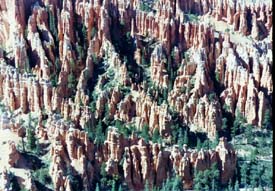
We drove to Sunrise Overlook, then to Sunset Overlook. We took a three-mile hike down Navajo Loop to the Queen's Garden, so named because a Hoodoo (Indian name for these incredible structures) in the area looks just like Queen Victoria. This is a beautiful, amazing place. After the hike, we drove to Inspiration Point, then on to Bryce Point.
Sunrise Overlook
(Or was it the Sunset?) |
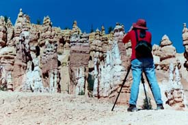
Taking Pictures of Queen's Garden |
We stopped at the lodge on the way back to get change and check it out. I stayed there on my solo road trip in the early 80's. I think Bill and I also stayed there on another trip. It's awful losing your mind.
We came back to the campsite, had a beer and got caught up on my journal. Bill started reading his new book, "The Tipping Point" but I caught him snoozing several times.
Kevin, the Ranger who gave the talk at the lodge, was excellent. He was also a Firefighter. He gave an amazing Powerpoint presentation on the philosophy of firefighting. He talked about how the three-month fire in Yellowstone changed some minds about the “Let Burn Policy.” The fire got out of control. He also discussed the Los Alamos fire. Some 200 - 300 homes were lost because the wind kicked up to 50 mph. That information didn't get to the right decision makers. He said the Berkley Hills fire was caused by someone burning excess lumber left from the construction of a new home. They didn't want to pay the money to haul the excess lumber away - so $3 billion was lost (including my friend Susan's home). He also blamed the fire crews. The flames were under control by dinnertime so both crews left. In the night, the fire took off again without anyone watching.
He mentioned the fire in Chicago in 1871 and in the same year, a fire in Wisconsin. The Wisconsin fire was the worst in history. Over 1500 people were killed. In those days, the people built everything out of wood. They also covered the streets with sawdust so the ladies wouldn't have to walk in the mud. The amount of sawdust on the street was a status symbol. It meant that the more sawdust, the better the lumber milling business in the town. The Wisconsin fire was a terrible tragedy.
>He also discussed fire containment by first digging trenches and how digging trenches with bulldozers causes more damage than the fire itself. He ended with the story of a fire incident in 1949 where 13 firefighters jumped from planes to fight a fire and all but three died. It was a very moving, emotional, educational talk.
After the campfire talk, we walked around a little in the moonlight. It's almost a full moon. Then to bed to read and sleep.
9/21/02 - Saturday - Bryce
Slept in 'til 8 - too cold to venture out. Bill went to the John, then discovered a woman was in the bathroom, so he got out of there. Later, we met the woman and her spouse / boyfriend? They were from Belgium living in Houston. They were a sweet, goofy couple. They slept in their car because there were no more campsites.
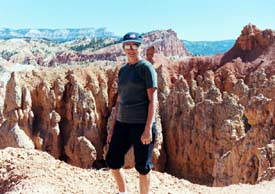
We had oatmeal for breakfast, then packed a lunch. We went on an 8-mile hike. We started on the rim trail adjacent to the North Campground. We hiked counter clockwise through Fairyland Canyon. We saw amazing hoodoos. The main hoodoo was Tower Bridge. We walked back to our campsite and had a coke. Then we went to the General Store for our $2 shower. It was wonderful.
Nancy on the Fairyland Hike |
View of Tower Bridge |
All cleaned up, we headed north out of Bryce through Ruby's (a town) and on to the Mossy Caves hike -- a short little hike with lots of water flowing in the stream and waterfalls. Then we drove to Tropic to have dinner. We ate at Doug's Place. We got there just in time to order from the lunch menu. I had a great burger and fries for $3.85 and Bill had an open face turkey sandwich with mashed potatoes for $5. We shopped at a few gift stores / general stores, then back to the campsite to brush our teeth and plan our evening.
We headed to the Lodge to fill out postcards and listen to another Ranger's program. Janie, the Ranger, was from Pittsburgh. She was sweet, overweight rookie who was just too excited about her perfect job. The topic was mountain lions. It was a full house and poor Janie was nervous. I slept through half of it - the kind of sleep where your neck collapses. Bill also slept a bit and there we were on the front row.
At 9, we came back to the campsite. Bill tried to make a fire, but the wood didn't burn. I read my mindless book, “The Bonesetter's Daughter,” and finally got to sleep.
9/22/02 - Sunday - Bryce to Escalante
Slept in ‘til 8 - really late for us. We had breakfast. Several birds wanted to join us. One even sat on Bill’s hat.
We packed up and headed down highway 12. We stopped at the State Visitor’s Center in Cannondale - a lovely, new place with lots of good information and free postcards. However, the guy at the desk seemed very nervous.
We drove to Kodachrome Basin. There were beautiful canyons. We hiked up a very steep terrain - Eagle’s view. I wanted to go to the top, but Bill said, we had enough view.
Kodachrome Basin
From the Eagle’s View |
Next we drove to the town of Escalante, population 800. It was an old Mormon town settled in the 1870’s. Escalante was named after an early Spanish Padre who developed trails all the way down to California. Interestingly enough, “escalante” also means steps and this place is loaded with huge, step-like formations. In the town, we stopped at a deli advertising free Internet. We split a yummy turkey sandwich in order to use the free Internet, but the free Internet didn’t work. Rick ran the place. We had to wait and wait. Bill was not amused. In town, we also got some ice, milk and beer. Nothing is open on Sundays, except the gat station convenience shops.
We backtracked to the State Park - Wide Willow Reservoir Campground within the Escalante Petrified Forest.
Wide Willow Reservoir Campground
Grand Staircase Escalante |
After we set up camp, we drove out of town (12 miles) onto the dirt road called “Road to Hole in the Rock.” It was interesting cowboy landscape, where the Mormon settlers, cattle, etc. crossed the area. About 12 miles in, we stopped at Devil’s Garden. It had the most amazing structures. We walked around, then had a beer.
Devil’s Garden
Grand Staircase Escalante |
Nancy in Devil’s Garden |
9/23/02 - Monday - Escalante to Capitol Reef
Neither of us slept very well, but up at 7 - lots of ground to cover. We had oatmeal, then packed up and took off. We stopped at the Post Office in Escalante to mail our cards, then off for a gorgeous ride up Highway 12 - spectacular views of Indian / Cowboy country.
We stopped at the Anasazi Indian Museum. The Anasazis, dating back to about 1200 AD, were the ancestors of other Indians - Hopi, Punta, and Navajo. The museum was nicely done with archeological digs out back. The Indians here lived in sub terrarium caves and climbed out via ladders to remind them that they came from the earth. The Indian community here was once a busy center, but they only stayed for about 75 years. Why did they leave? No one knows.
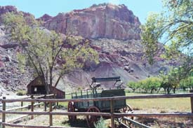
Back on the road again. We got to Capitol Reef National Park about 11 am. We found a campsite in Fruita Campgrounds. Fruita was once a Mormon settlement with lots of orchards. In the 20's, the site became a national park and then the Mormons began leaving. The fruit trees left behind are still producing, thanks to the rangers. Campers can pick the fruit. Whatever they can eat in the campground is free. What they take is only 75 cents a pound. Bill and I picked apples and pears right behind our campground bathroom. We set up camp, then had tuna sandwiches.
We visited the Visitor's Center - always a source of good information. We stopped at some of the old Mormon landmarks. The blacksmith's shop was still fitted out with all of the old tools. We listened to a tape of someone remembering what a paradise Fruita was at the turn of the 19th century. Then we visited the Gifford barn and homestead. The house was cozy with a loom, spinning wheel and other quaint necessities. The prices in the gift shop were out of site -- $7.95 for a little jam or soap - Forget it!
Old Gifford Homestead |
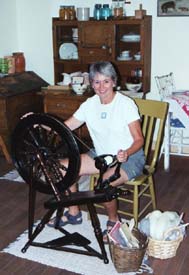
Nancy Spinning
Inside the Old Gifford Home |
We took the scenic road south of the park. Our first stop was Capitol Gorge where the settlers made their way through in covered wagons (I suppose). We hiked up the wash to the pioneer register - a big rock with names and dates of the pioneers passing through - so interesting. We also saw some Indian petroglyphs, but they were faded by time. At the end of the trail up the wash were these natural rock formations high up in the cliffs that served as natural “tanks” for collecting water. The pioneers always stopped here for water on their way westward. We had to scramble up some of the cliffs to view about 7 to 10 of these water tanks. What a beautiful setting!
After our two-mile hike, we got back into the truck and headed back toward the campground on the scenic drive. We stopped at the Grand Wash to access the Cassidy Arch trail. It was 3:30, getting late. We debated whether to take the hike or not. It was about 4 miles with huge elevation gains. We were glad we decided to take the hike. It was wonderful with amazing views. It's called the Cassidy Arch because Butch Cassidy, the famous train robber and general outlaw, hid from the long arm of the law in these here parts. The arch was magnificent. We finished the hike at 5:30 and returned to our tent for beer and spaghetti. We also picked fruit from the orchard in that wonderful twilight time just before sunset.
Grand Wash
Access to Cassidy Arch Trail |
Fern's Nipple
Cassidy Arch Trail |
9/24/02 - Tuesday - Capitol Reef to Moab and Arches National Park
Got up about 7:30-ish. The deer were grazing just outside our tent. What a fun way to wake up. I ran around snapping pictures of the deer among the tents and RVs.
We had breakfast and packed up. An “older” couple (about our age) next to us in the campground (from Santa Ana) had the same camping style as us (rare for old birds). They had a little white pick up (no big RV) and an old tent. People our age usually don't “rough it.” They were, however, very impressed with our foam mattress. Works great - I made a cover for it from flannel sheets.
On the way out of the park, we stopped at the old Mormon schoolhouse (1890 - 1941). A ranger had the classroom all set up - readers on the desk, maps on the wall, writing on the chalkboard and an old flag with 48 stars hanging in the front of the room. She was waiting to do a presentation for a school field trip. We looked at pictures of the early Mormon children who attended the school. Their little faces looked so sad and tired. They had a tough life - had chores to do before school and then a long walk to school.
Old School House
Capitol Reef |
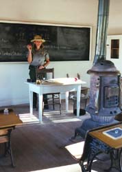
Ranger
At the Teacher's Desk |
Next, we stopped at the petroglyphs. One woman viewing the petroglyphs was so excited she was almost screaming. The petroglyphs were just so-so, but the walk along the boardwalk under the trees was nice. There is a very special feeling about this place. We loved the orchards everywhere in Fruita.
We stopped at another Mormon log cabin on the way out of the park. The Burhen family of 10 lived there. I can't imagine life like that.
From Capitol Reef to Moab was a 3-hour drive. We arrived in Moab about noon. We got a room, at the Red Stone Inn. Nice, friendly place with laundry, showers and picnic facilities. However, we had lunch at the Moab Diner. We had a yummy chicken sandwich with an Ortega chili on top (called Kokopelli Chicken).
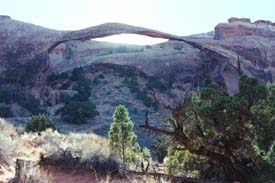
After lunch, we went to Arches National park and took the 5.4-mile Devil's Garden Hike. Great hike with lots of side trips to the individual arches - Tunnel, Pine Tree, Landscape (most famous), Partition, Navajo, Wall, Double O and Black Arch. We got to scramble over slick rock and up on “fins” (high rock structures).
"O" Arch
Devil's Garden Trail |
"Horizontal" Arch
Devil's Garden Trail |
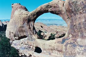
At sunset, we took the hike to Delicate Arch, 3 miles roundtrip. On the hike we also saw the Wolf Ranch and some petroglyphs. These petroglyphs were dated later (circa 1700) because the drawings included horses.
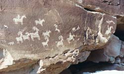
Petroglyphs behind Wolf Ranch
on Delicate Arch Trail |
 Tunnel" Arch
Devil's Garden Trail |
We got to the magnificence Delicate Arch at sunset. There were lots of people sitting on the cliff with cameras posed on tripods, waiting for the moment the sun would cast its last golden rays on the arch. The clouds came out and dopes would walk right under the arch ruining the shot for everyone. A raven (or was it a crow?) flew through the arch for our entertainment. Bill and I gave up waiting for the precise sunset photo and headed back down the trail into a beautiful sunset - Great day!
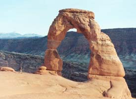
Delicate Arch
At Sunset |
We got back to our motel, showered and went across the street to Smitty's, a local family owned restaurant. There were lots of locals with a few travelers sprinkled in. We had the worst chicken fried steak ever. How could they ruin a chicken fried steak? We went back to our motel and then watched the dumbest movie ever - “Evolution.” Things have taken a turn for the worse.
9/26/02 - Thursday - Moab to Canyonlands (Island in the Sky)
Up early at 5:30 to make sure we could get a camping spot at Dead Horse Point State Park (near Canyonlands Island in the Sky). As we arrived, Bill said, “Hope we’re not too early!” We had breakfast at the Moab Diner again (this time with a coupon). The news headlines in the paper said something about the struggling economy and Bush's plans for war. We don't even want to know ….
We drove to Dead Horse Point, about 45 minutes from Moab and got camping site #17 - the only one available at that time. We made site #17 our home in no time.
Canyonlands (Island in the Sky)
Dead Horse Point Campground |
After setting up camp, we drove into the Island in the Sky section of Canyonlands National Park. First stop, as usual, is the Visitor's Center. We talked to the ranger on duty and made our hiking plans. First we drove down to the Grand View Point Overlook and did a little hike to the rim. Next we took a 1.5-mile hike to White Rim Overlook, followed by a 2.5-mile hike to Murphy Point and back.
Bill Enjoying the View and a Snack
Murphy Point - Canyonlands (Island in the Sky) |
We drove to Upheaval Dome and had a picnic. The chipmunks and mountain Blue Birds tried so hard to get our food. After lunch, we hiked a mile to the Upheaval Dome Overlook. No one is sure of its origin - it could be a result of a meteor or from the salt that pushed it's way up from underneath the ground. We drove to Mesa Arch - grand view. Someone wanted us to take their picture - so we exchanged the favor.
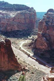
Next we went to Neck Spring Overlook (Schafer Trail) and saw a view of the windy road to the bottom of the canyon. Can’t believe that this was the trail where the cattle were once herded up from the canyon. In the 1950s, the old cattle trail was made into a rough road for the uranium miners. We stopped at the Visitor Center's on the way out of the park. Bill called David while I hiked down a trail with some other old geezers to snap a few more pictures.
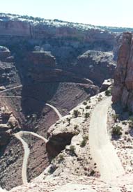
Schafer Trail (Old Cattle Trail)
Canyonlands (Island in the Sky) |
We returned to the Dead Horse Point Visitor's Center and then did the Nature Trail out back. It was beautiful. We could see the potash solar evaporation ponds. Then we drove to the magnificent overlooks in Dead Horse Point.
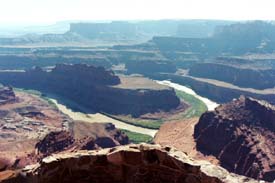
Dead Horse Point State Park - Overlook
Canyonlands (Island in the Sky) |
Afterwards, we came back to camp and had a beer. This campground is SET-UP. Even has a streetlight, another light over the table and a covered eating area with cabinets. We made Hamburger Helper's version of Beef Romanoff (had better) and a salad and bread. We went into the tent right at sunset and read our books until 10.
9/27/02 - Friday - Canyonlands (Island in the Sky) to Canyonlands (Needles)
Had breakfast, packed up and left. We stopped in Moab for gas and grub, then drove to Needles, another section of Canyonlands. We found a campsite at the Squaw Flat Campgrounds. They were going fast. I made tuna sandwiches while Bill set up the tent.
Squaw Flat Campsite
Canyonlands (Needles) |
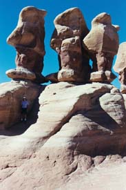
It's very windy here, but beautiful with the threatening clouds overhead. We drove to Elephant Hill down a gravel road, then took a six mile hike to Chesler Park. When we parked the truck, there was howling wind and a few sprinkles. We waited and the mini storm blew through so we had a wonderful hike. We followed the ducks (three rocks stacked up to mark the trail) through all socks of terrain. The trail featured such things as deep joints in high rocks, slick rock, sandstone, deep gullies and the most amazing views. So fun and so beautiful. I snapped a lot of photos, much to Bill's chagrin. I can still hear and feel the powerful wind as we crossed into Chesler Park - a place with wonderful needle and mushroom rock formations. After we explored Chesler Park, we turned around and headed back to our truck. I put my camera in Bill's backpack so I wouldn't be distracted - we needed to haul ass.
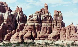
Chesler Park - Needles |
Bill hiking to Chesler Park |
We got back to the parking lot and a beer about 4:15. We drove to the Visitor's Center and decided we had time for one more hike - a little .6-mile one to Cave Springs, including a climb up two ladders. We saw Indians rust-colored paintings and little hand prints, the place where the cowboys set up their work area (branding, etc.) under the natural watershed rock formations.
After the hike, we returned to the camp and heated up our left over Hamburger Helper concoction - tasted a little better the second time around. We washed dishes and made it to the ranger's 7 pm talk. Cath, our Ranger de jour, gave a very good program on animals of the night - Predator vs. Prey. She told how all the animals wanted the poor little bunny for dinner. We showed us several skulls of animals (and man) to illustrate how the sense of sight, hearing and smell makes us either predators or prey. “Eyes to the side, run and hide” - means you are prey. “Eyes to the front, need to hunt” -- means you are a predator. She did lots of demonstrations. We made our ears like mule deer to catch more sound. Cath had us smell All Spice, then she sprayed our noses (like moist coyotes’ noses) and had us smell it again to demonstrate how moist noses pick up more of the scent. Fun, interesting program.
We went back to our tent to read. Looks like rain. It was very windy during the night. At times I thought the wind would blow our little tent away, but it stayed anchored. The reports were that some tents blew away.
9/28/02 - Saturday - Canyonlands (Needles) to Mesa Verde
Had breakfast and packed up. We stopped at the Visitor's Center on the way out of Needles seeking advice about the other areas. Should we make a detour in order to see Natural Bridges and Valley of the Gods? We decided to go over the mountain pass to Hovenweep, then on to Mesa Verde. It was a beautiful drive over the mountains, then through Montecello, then Blanding. We made a stop in Blanding for groceries and ice. Blanding had a wonderful Welcome Center - they gave out free samples of goodies - potato chips, soap, power bars, etc. The little museum in the Center had pictures of the early Blanding Mormon settlers.
We drove to Hovenweep (means deserted desert) and had our lunch in the picnic area outside the Visitor's Center (tuna sandwiches again). After lunch, we took the two-mile plus hike through Hovenweep's Indian ruins perched on a canyon. The tower structures along the canyon still remain today - 1,000 years later. We saw twin towers, round tower, square tower, etc. They had a lot of towers. It was a nice setting, then the clouds and thunder moved in - so we hurried to the truck. Yucky weather has finally caught up with us.
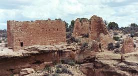
Hovenweep |
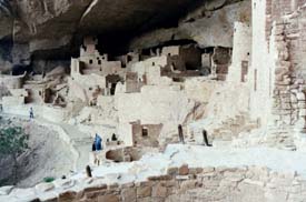
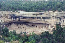
We drove to Cortez, Colorado and stopped at the Welcome Center to get coupons for a motel. We ended up at the Day's Inn outside of Cortez for $49 / night - not too bad. We got settled in and then drove about 20 miles down the road into Mesa Verde National Park. It was raining (lots of slow cars ahead). We finally made it to the Visitor's Center in time to get tickets for the 4:30 pm Cliff Palace ruins. We met our Ranger, Graciela, and the small, mellow group of people. Mellow except for Thomas, the hyperactive kid whose parents didn’t do a thing to control him. He and his sister Grace sat on the walls (a major NO NO) and were generally annoying. The Ranger tried to control them.
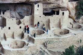
Cliff Palace Ruins
Mesa Verde |
In spite of the kids from hell, we did learn a lot on the tour from Ranger Graciela. The first Indians here were nomadic - the Anasazis. (Anasazi is a pejorative term meaning invading Indians. They have a lot signs and books to change to “Ancestral Puebleans”. The more politically correct term . The term Anasazi is plastered everywhere.) Anyway, these nomadic Indians chased animals into the mesa here about 500 AD. Then they said, “What the heck, pretty nice place - let’s stay.” So they built homes on top of the mesa. The first homes were called pit houses. Next came the pueblos (equivalent to villages / condos) and then in 1200, they built these amazing dwellings into cliffs, under alcoves. They are so many cliff dwellings in this region. The water source was close to them. It seeped through the sandstone and collected under the alcoves, close to their dwellings.
The Cliff Place had amazing structures - Kivas (round buildings for religious ceremonies, built into the ground. They constructed a webbed wood roof with plaster on top. The top was so strong; it served as a plaza in the marketplace. Inside the Kiva was a small fireplace, a deflector wall to keep the air / breeze away from the fire, a ladder entry through the roof, a ventilation system, like a reverse chimney. There were several small Kivas in the Cliff Palace.
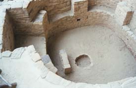
Kiva
Cliff Palace - Mesa Verde |
Archeologists speculate that Cliff Palace served as the administration center of the area. The Anasazis came to transact deals, conduct religious ceremonies, etc. In 1300, only 100 years after the Indians built these cliff dwellings, they left. The reasons are unsure. There was a 25 year drought. Others speculate they over farmed the land (used it for 800 years to grow corn, beans, maze), or enemies came (little proof of this). The Anasazis here scattered, becoming Hopis, Punas, Navajos and other tribes. Interesting enough, only 400 bodies have been found here. Autopsies show bad teeth, worn away from eating stone particles. They ground their corn on stones (mano and metate). Autopsies also showed a lot of malnutrition and many cases of emphysema (maybe from too many smoke filled rooms / Kivas). However, there was little indication of broken bones from falling off these high cliffs. The entrance to these cliff dwellings are over sheer cliffs using hand and foot holes - looks very scary. The Anasazis also raised turkeys to eat. Interesting place.
After our tour, we went to the museum. We left the park at 6:30, then drove back to Cortez for dinner. We ate at a place in town called “Homestead.” It was cozy and had good home cooking. I had the roast beef / mashed potatoes and Bill had a hamburger (for Zi).
We went back to the motel and to watch a little HBO and read my book.
9/29/02 - Sunday - Mesa Verde to Pagosa Springs
Up at 6:30. Had a pretty good continental breakfast at the motel - coffee, cereal, muffins, juice, etc. After breakfast, we drove to the Mesa Verde Visitor's Center to get suggestions from the Ranger. In the museum, we learned about the early archeologist in the area. He was from Sweden. He sold artifacts that he found here to a friend who later gave it to Finland. The Swedish archeologist also presented a photo exhibit in Spain, commissioned by the Queen of Spain, to commemorate the 400-year anniversary of Columbus discovering America. That Swede got a lot of mileage from Mesa Verde.
We took the 10:00 tour of the Balcony House. We were glad to see that Thomas and his family were on the 9:00 tour. Lauralyn was our guide. She was smart and interesting and reminded us both of Karen Hartman. I was assigned leader of our group (the honor usually goes to a kid, but none on this tour). There were only about 20 in the group (usually 60 or more). We learned about farming - the good topsoil is blown in from the faming states. The Indians ate pine nuts from the pinecones. They used the Yucca plant for rope, soap, needles, shoes, and shampoo, just to name a few. They used bark from certain trees for diapers. (No Pampers here!) The Indians threw their trash over the side of the cliff - body waste, bodies, etc. However, they didn't think of trash like we do. Everything they tossed was what they made, not like throwing away candy wrappers, etc.
Balcony House was probably the ceremonial center. Some of the poles from the roof line up with the sun position at the summer solstice. The entrance to the Balcony House was straight up ladders -- much more difficult than the Cliff Palace entrance. (Lucky Lauralyn selected me as the leader!) There were tall ladders perched on the cliff and an 18-inch crawl space to pass through. It was fun.
Balcony House Ruins
Mesa Verde |
'Next we drove around the Top Mesa Loop, stopping at all the overviews, or lookouts of Soda Canyon and other canyons filled with cliff dwellings. We also stopped at several of the early pit houses and pueblos constructed before the Indians moved down into the sides of the canyon.
Spruce House Overlook
Mesa Loop - Mesa Verde |
We had a picnic lunch. Made it back to the truck just as the rains came. We waited it out in the truck while I caught up in my journal.
The rains let up so we could see Sun Point View. We could still hear thunder. Next, we hiked down to the Spruce Tree House behind the museum. Spruce Tree House was reconstructed to get the flavor of one of these dwellings. There were rangers on hand, but no organized tour into Spruce Tree House. We went down a ladder to experience a Kiva. There were three Amish women also experiencing the Kiva.
We took a 4-mile hike to the petroglyphs. It was a wonderful hike - lots of scrambling. There was a loud Indian family behind us, so we hurried up to get some peace and quiet. The petroglyphs were interesting. There were lots of symbols from the various Indian clans - parrots, deer - can't remember the others.
We got back to the museum just in time for another big storm. Good-bye Mesa Verde. It rained heavily - terrible drive down the road to Pagosa Springs.
We stayed at the San Juan Inn for $51. The place was recommended by Brother Dave. Based on the suggestion from the cute gal at the front desk, we had dinner at the Family Junction. Bill had crispy fried chicken and I had chicken fried steak (to erase the memories of Smitty's in Moab). There was a Chinese checkers type of game at each of the booths. I did poorly. We went back to the room and swam trough more channels, then to bed.
9/30/02 - Monday - Pagosa Springs to Colorado Springs
After breakfast in the room, we checked out the cute little town of Pagosa Springs, noted for their healing waters. For $12 each, we could experience the healing, but no thanks.
We drove through some gorgeous Colorado country. We did have to stop for 30 minutes while the road crews were blasting out caves / roads? During the wait, I finished my book.
We stopped for a picnic lunch at Fort Garland (circa 1858 - 1883), then toured the fort. I found it most interesting. It was mainly a training fort. The men were there to train for battle (Indians, Civil War) and to help the settlers. Kit Carson was the commander of the fort for several years beginning about 1860. He was an old fur trapper / Indian Scout. He married Josefa, a young, beautiful Mexican from a wealthy family in Taos. They had six children when Carson was assigned to Fort Garland. After Fort Garland, they retired to their lovely home in Taos. Josephine died having her 7th child at age 25. Then Kit died one month later.
Fort Garland had the first Black soldiers, called Buffalo Soldiers by the Indians (because the soldiers were dark and appeared to have fuzzy hair like the buffalo). There was so much racism toward the Buffalo Soldiers.
We arrived at Dave and Barb's around 4. Barb was out doing a landscaping project. We talked to Dave, then got into a huge political debate. Dave is a Bush supporter -- need I say more?
When Barbara got home, we picked up some Chinese food to take to our niece (their daughter) Gina's for dinner. We had a lovely evening getting to know Gina's little family - husband Pat and sons Silas and Eske.
10/01/02 - Tuesday - Colorado Springs
After breakfast, we went to the Garden of the Gods - beautiful, but boring. So tame with sidewalk paths and mini structures. This is an urban park. We're jaded with visions of wide-open, magnificent formations.
After a look around, we drove to Manitau Springs. We stopped at the Visitor's Center and talked to a cute little volunteer named Andy. He suggested we have lunch at the Breadhead. It was good. Manitau Springs is a darling quaint, rich town.
After lunch, we drove to Mueller State Park and took a couple of hikes. We saw a deer on one of the hides. We hiked by an old log cabin with an old stove still left in it. The hikes were beautiful with the Aspen just beginning to change colors and mountaintops in the background.
Bill Hiking in
Mueller Colorado State Park |
We decided not to drive to Pikes Peak because the toll road costs $25 and besides, who wants to drive to the top of a mountain.
Coming back to D & B's, we got lost in the Garden of the Gods. It was like a rat's maze you could not escape.
Finally made it back and then took D & B out for Thai food at a place called “Wild Ginger.” It was pretty good. D & B haven't experienced much Thai food. They seemed to like it.
Came back to the house and took pictures of D & B in the garage with all their fancy motorcycles while Bill surfed the net. A bad storm is predicted. We were going to D & B's condo in the mountains, but with no tire chains, we changed our plans to take a southern route, down into New Mexico.
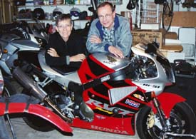
Dave and Barb
With Their Motorcycles |
10/02/02 - Wednesday - Colorado Springs to Bandelier
Had breakfast with D & B, said our “Good-byes” and hit the road about 7:30. The weather is bad, lots of fog and snow in the forecast. But as soon as we crossed the border into New Mexico (over a mountain pass), the skies cleared up.
We arrived in Taos about 12:30 and we were hungry. Traffic was terrible. We had to pay $5 for a place to park. The place was so crowded, so commercial and so expensive. Bill did not find it charming. To make matters worse, streets were closed off because crews were shooting a movie right in the heart of town. The film, “Off the Map,” stars Sam Elliott, but we didn't see anyone famous.
After stopping at several eating spots, finally found an agreeable place to eat, but then had to wait and wait for a table, then wait and wait for a sandwich and a bowl of chili. We were not amused.
After lunch, tried to explore Taos. First went to Governor Bent's house / museum. He was murdered in a rebellion in his own house. The ticket taker said his wife and daughters managed to dig their way through an adobe wall to escape. However, an Indian later told us that the entire family was murdered. Who speaks with forked-tongue?
Next we walked through the old Taos graveyard and found Kit Carson's grave. We stopped at Kit and Josefa's house, but decided not to spend the time or money.
We drove out to the Taos pueblo, the oldest, continuously-occupied place in the U.S. They occupied the same houses for over 1,000 years. It was expensive to visit the pueblo -- $10 each, plus $5 for the camera, but I thought it was worth it. We took a tour with a beautiful Indian girl named April Winter. We saw the church, the graveyard, where they have to remove old crosses to make way for the new crosses. (They only remove the crosses, not the bodies.) We saw where the old church was destroyed. April told us 150 women and children were killed in the church. The white man did it in retaliation for the Indians killing Gov. Bent (and other town dignitaries, such as the Judge).
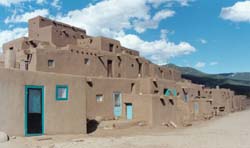
Taos Pueblo |
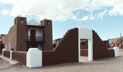
St. Jerome Chapel
Taos Pueblo |
We also saw the little beehive ovens outdoors used for cooking. No one within the pueblo can have electricity. After the tour, we went to several gift shops. The shops are where the people live, very cozy rooms. We bought Amy and Brian a clay sculpture called “The Storyteller.” The artist, Georgia Ann Hale, who signs her work Juanita, is a sweet grandmother of 11. She gave us a peach pie she baked in her outdoor oven. It was so good.
We left Taos Pueblo and got lost trying to avoid Taos Proper. We finally found the right road to Bandelier National Monument.
We arrived at the park about 5:30, paid $10, set up the tent and made spaghetti dinner and salad. We spent most of the evening in the tent planning the last few days of our now “southern” trip. There were some raindrops on the tent. Hope we're not in for it.
Bill at the Campsite
Bandelier National Monument |
10/03/02 - Thursday - Bandelier to Cuba
Had a good rest. The tent was a little damp. We had oatmeal for breakfast and packed up everything but the tent (left out to dry).
We went down the road to the Visitor's Center. (No signs to the Visitor's Center, so had to ask the road crews where the heck is it.) The center was just opening when we arrived at 9. We got some information and then did our first hike through some wonderful cliff dwellings. I resent the fact that this place is named Bandelier after Adolph Bandelier, some rookie Swiss archeologist who first explored this place. It was the Anasazis who built it, and established an incredible civilization in these wonderful canyons until about 1600. We loved exploring the caves, climbing up the ladders. We added an extra mile to the hike in order to climb up into the ceremonial caves high up into the cliffs. Two women on the trail were terrified and couldn't make it - 'twas nothing.
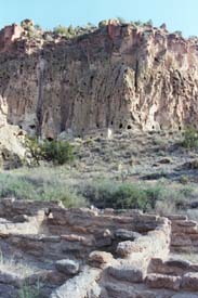
Bandelier
Nature Trail |
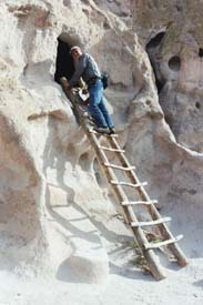
Bill Exploring
Bandelier Dwellings |
We returned to the Visitor's Center. They have a terrific museum. There was little verbiage, mostly displays and sweet, thoughtful scenes of everyday life (i.e., a kid handing his mom a broken hemp sandal for repair). I had to get another roll of film at the gift shop. (Bill is not pleased with my active shutter finger.)
We returned to the campsite to retrieve our dry tent, then headed down the road for our next hike in the Tsankawi section of Bandelier Monument (a separate section north of the main park). We took a three-mile hike to the most amazing site - tons of cave dwellings and petroglyphs and pieces of pottery and arrowheads just laying around. We could really get the feeling how these folks lived. The paths were worn down trenches (about 6 - 12 inches) in the sandstone. The place cries for a good archeology survey, but maybe it's better left alone. The wind was really blowing up on the mesa. We finished the hike and then made peanut butter sandwiches for lunch.
After lunch, we drove to Los Alamos to visit the Bradbury Science Museum. It was free and put together by the University of California. We saw a replica of Fat Boy, the first A-bomb and learned all about Oppenheimer and Project Y commissioned by FDR to build the bomb to win the war. It was so amazing to see all the original typed letters to the scientists from FDR. Typed letters are a thing of the past. Other displays showed the ongoing research still conducted at the lab (human genome project, mapping DNA, robotics, etc.). Most fascinating to me was this robot that looked like a cockroach. His job was cover open areas with buried landmines, then get blown up. Better him than real folks. Better to lose a low-cost robot to a landmine than a human leg or body. So many exhibits -- hard to focus on the content.
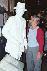
Nancy with Mr. Oppenheimer
Bradbury Science Museum, Los Alamos |
The museum was a nice, interesting place, but a really goofy woman was at the main desk - she was scary goofy.
After the museum, we went to the Los Alamos Welcome Center to figure out if we could really manage to visit Chaco Canyon before we head home. It's out of the way and 21 miles down a dirt road. The woman there was most encouraging, so off we went to Cuba to get a motel.
The weather was starting to look bad - cold and windy. We had a nice drive to Cuba through the Jemez Mountains. We saw the biggest caldera. They think it was caused by a volcano blowing apart, but not sure. We also saw burnt trees from the terrible Los Alamos fire that was set as a control burn and went out of control. 200 - 300 homes were destroyed. We saw Battleship rock and took a peak at the Jemez Monument where a mission was built upon a pueblo. We didn't want to pay $6 each or spend the time exploring, so we just took a peak out back.
We arrived in Cuba about 5:30 and checked into the Frontier Motel for $35 / night. Not too bad - I think the sheets are clean. The shower is to die for - blasts you out of the bathroom. Feels like I had a massage.
There are a lot of freaky people in this strange, ugly place called Cuba - lots of fat Indians and retarded looking kids with oversized ears and alien features. It's like the Twilight Zone. We decided not to eat at the fancy Mexican cantina (with normal looking people), but opted for the café next to our motel. Got a good Mexican combo plate for $6.75. The only problem was this incessant smoker keep following us at we changed tables to get away from him. Weird - the poor waitress didn't know what was up.
We got back to our room and out of the cold, windy night. The Frontier Motel seems to have filled up with hunters and their guns.
We watched “Survivor” in Thailand and got organized for an early morning departure.
10/04/02 - Friday - Cuba to Needles (via Chaco Canyon)
Woke up at 5:30, got dressed and went down the road to the Cuban Café (owned by Bobby and Margie) for breakfast. I loved the cozy little spot. Had a great breakfast for $3.40 and coffee was only 65 cents - unheard of. These folks don't get out very much. The walls were filled with pictures of family and the locals. It looked like the owner's family was eating breakfast, talking, laughing and reading the paper together. It was good to have a pleasant experience in Cuba. There was also a massive collection of toy trucks lined up on shelves.
>After breakfast, we headed to Chaco Canyon, an hour and 20 minutes down some rough roads. We arrived exactly at 8:00, the precise time the Visitor Center opens. It's scary how punctual we are.
We were able to see about 5 or 6 different ruins - what amazing sites, built by the Anasazis between 800 and 1300. This place would be over run, like Mesa Verde, if it weren't tucked away in an isolated corner of New Mexico with 21 miles of dirt road to get to the entrance. What a jewel it is.
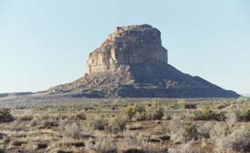
Chaco Culture National Historical Park
New Mexico |
The area is found to be a trade center. They found all sorts of shells from the ocean and from Mexico, there were feathers from Parrots and Macaws. Also, 90% of all the turquoise was found within this region. The draftsmanship of the walls was incredible. The stones / sandstone were perfectly cut. All the ruins lined up with the movement of the sun and moon.
At Pueblo Bonita, we took a ranger-guided tour. She was good, but two obnoxious guys keep trying to impress us all - hate that. The ranger told us they found only a few burials and two of the burials contained skeletons of two guys that were six feet tall - rare for that time when the average height was 5' 4". It's curious why the designs of these villages were like the ones found in Mexico. This whole area is miles and miles - so it took a lot of cooperation to build and develop in such an orderly, consistent fashion. A definite must see.
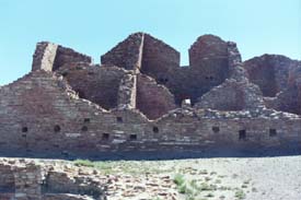
Chaco Canyon Ruins |
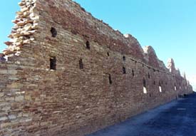
Chaco Canyon
Moon follows Line of Wall |
We saw a little snake wind its way around one of the Kiva walls. Wish I had my hiking boots on, instead of sandals.
We ran out of film so we declared Chaco Canyon finished. We had a peanut butter sandwich in the parking lot, then at 12:30, started our long trek home.
We made it to Needles, California at 7-ish and got a cheap motel room ($25) at the River Valley. A sweet Indian woman (from India) was at the front desk. Based on her recommendation, we had dinner at the California Pantry. Watched a little TV, then to bed.
10/05/02 - Saturday - Needles - HOME!!!
Up at 5:30, breakfast at the California Pantry. We opened the place up, along with two very young-looking police officers. Our bleach blonde waitress was flirting with them.
We hit the road by 6:30. Beautiful drive on I-40 through the desert with the sun rising from our backs. However, there were lots of trucks on the road. We stopped in Barstow for gas and a pee. The road was really congested around the L.A. vicinity. Welcome back to reality.
A wonderful trip - good to be home with so many special memories.
|